|
|
|
| Welcome to Turizm.net! |
CAPPADOCIA
|
|
The Taurus mountains, which are technically part of the Alpine chain, in their creation 60 million years ago, caused the warping of the Anatolian plateau. The resulting volcanoes, including the spectacular Mount Erciyas and Mount Hasan, produced the tuff from which the unique landscape of Cappadocia is formed.
It took millions of years for the ash from these volcanoes to form a layer of tuff, covered in places by a further layer of basalt lava. The basalt ultimately cracked and split under attack from the weather and rainwater seeped down through the cracks and splits to slowly erode the tuff itself. The natural effects of alternating very hot and very cold weather and the rain and the wind breaking down the rock's resistance caused (and continues to cause) the emergence of the tall cones of tuff capped by hard basalt which the Turks call Fairy Chimneys.
The valleys are sheltered and fertile with an almost temperate climate. The tuff is easily worked and, for milennia, has provided dwellings and and storerooms, both above and below ground, for smallholders. Despite it's increasing popularity with visitors, Cappadocia is very much home to small farmers who can still be seen every day tending their orchards, vineyards and field crops and riding their donkeys home to their cave houses. Source: |
|
Home |
Turkey I
Cities & Sites
I Hotels I
Blue Cruise
I Tours I
Contact Us |
Search I
Ask for a quote to compare:
Cruises I
Biblical Tours I
Incentive Travel I
Hotels I
Transfers
Copyright � 1995-2016 Turizm.net
All rights reserved.
 The name of the ancient province in central Anatolia. The
irresistible region is created through violent eruptions of the volcanoes Mt. Erciyes
(3,916 m.) and Mt. Hasan (3,268 m.) three million years ago. Places which are visited most
in the region are : The G�reme Open -air museum with its carved churches, the Ihlara
Valley, the underground cities of Kaymakl� or Derinkuyu, the fairy chimneys, Avanos with
its handicrafts, Zelve and �rg�p.
The name of the ancient province in central Anatolia. The
irresistible region is created through violent eruptions of the volcanoes Mt. Erciyes
(3,916 m.) and Mt. Hasan (3,268 m.) three million years ago. Places which are visited most
in the region are : The G�reme Open -air museum with its carved churches, the Ihlara
Valley, the underground cities of Kaymakl� or Derinkuyu, the fairy chimneys, Avanos with
its handicrafts, Zelve and �rg�p.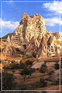 There is no historical record of activity from
these ancient volcanoes (and they certainly won't interrupt your holiday) but there are
three surviving memorials, although it is likely that these were created by people who had
heard about the eruptions through folk history rather than having actually witnessed it
themselves. One of the wall paintings in �atalh�y�k (which is incidentally one of the
oldest paintings known to archaeology) shows an eruption as does an ancient engraved coin
from Caesarea (Modern Kayseri). The remains of a Persian temple dedicated to fire near
Mount Erciyas show that this volcano was once regarded as sacred.
There is no historical record of activity from
these ancient volcanoes (and they certainly won't interrupt your holiday) but there are
three surviving memorials, although it is likely that these were created by people who had
heard about the eruptions through folk history rather than having actually witnessed it
themselves. One of the wall paintings in �atalh�y�k (which is incidentally one of the
oldest paintings known to archaeology) shows an eruption as does an ancient engraved coin
from Caesarea (Modern Kayseri). The remains of a Persian temple dedicated to fire near
Mount Erciyas show that this volcano was once regarded as sacred.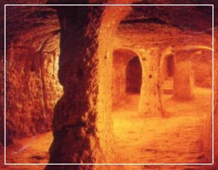 Where there is no basalt layer to protect the tuff
lovely valleys have been formed connected to the plateau by steep canyons of andesite and
basalt. The canyons of So�anl� and Ihlara are particularly stunning examples, Ihlara
canyon being 650 feet in depth in some parts.
Where there is no basalt layer to protect the tuff
lovely valleys have been formed connected to the plateau by steep canyons of andesite and
basalt. The canyons of So�anl� and Ihlara are particularly stunning examples, Ihlara
canyon being 650 feet in depth in some parts.